(CNN) — A storm system will finally lose some steam on Tuesday after fueling a multi-day severe thunderstorm outbreak with several tornadoes in the central US.
The system is pushing south and east, creating an expansive, albeit more muted, risk of severe storms that stretches from the US-Mexico border to the US-Canada border.
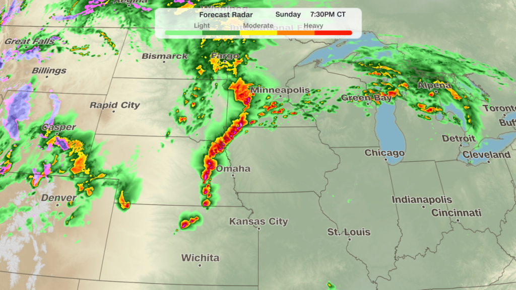
Since Saturday, the system has produced dozens of reported tornadoes, mostly centered around Nebraska, Iowa, Kansas and Missouri. An EF3 that struck St. Libory, Nebraska, on Sunday is the most powerful tornado of the event so far.
The thunderstorms have also produced flash floods in Iowa, Kansas, Nebraska and Indiana. Water rescues were reported on Monday in Martinsburg and New Pekin in Washington County, Indiana, according to the National Weather Service.
If that wasn’t enough, the weather system’s strong winds have also caused several wildfires to spread rapidly through tinder-dry vegetation in the southern High Plains.
Severe storm and tornado potential will decrease on Tuesday as the weather system pushes east. Still, there is a Level 2 of 5 risk of severe thunderstorms over an expansive area from Texas to the eastern Great Lakes and northern New England. Damaging winds and hail will be the primary threats through Tuesday afternoon and evening.
Heavy rain could also trigger flash flooding on Tuesday. The Lower Ohio Valley and parts of central and eastern Texas are most at risk.
Days of storms hammer central US
Supercell thunderstorms produced several tornadoes and egg-sized hail across Kansas and Nebraska Monday evening.
A classic stovepipe-shaped tornado cut through farmland in Richardson County, Nebraska, causing limited damage and no injuries, county Emergency Management Director Brian Kirkendall said.
The National Weather Service issued a rare tornado emergency in southeastern Nebraska Monday after a tornado was observed in Pawnee County. No damage was reported in Pawnee County from the tornado, emergency management officials told CNN.
It was the second tornado emergency — the most significant kind of tornado warning — of the event. The first came Sunday evening for an EF1 tornado that hit near Hebron, Nebraska, in Thayer County, just over 10 miles north of the Kansas border.
No homes were damaged or destroyed and no injuries were reported as of Monday afternoon, Director Colt Farringer of Thayer County Emergency Management told CNN.
On Sunday, a tornado hit north of Grand Island, Nebraska, in the town of St. Libory in Howard County.
Multiple structures were damaged, and video at the scene showed two people and a dog being rescued from the basement of a collapsed home. No one was killed or injured, according to Howard County Emergency Management. The tornado was rated an EF3 with peak winds reaching 160 miles per hour, according to the National Weather Service.
Monday’s storms also charged across the Great Lakes with destructive winds. Hurricane-force wind gusts were clocked at Chicago’s Midway Airport (79 mph) and near Grand Rapids, Michigan (81 mph).
Extreme wildfire threat
Wildfires in the southern High Plains erupted to life and exploded in size over the past few days after being fueled by high winds, low humidity and drought conditions.
Most notably on Monday, the Stinky Fire in the Texas Panhandle’s Potter County broke fire lines and forced new evacuations. The fire is over 2,500 acres with 20% containment, and is currently threatening 300 structures, according to the incident page.
It’s one of several wildfires burning in the Texas Panhandle. To the south in Randall County, more than 55,500 acres have burned in the Hunggate and Chocolate Chip fires. A BNSF railroad trestle was lost in the Hunggate fire last week.
The Sharpe Fire has burned more than 44,000 acres from Oklahoma across the state line into Colorado and is 10% contained. A mandatory evacuation order was issued for residents in and around Campo in Baca County, Colorado, on Sunday afternoon over fears the fire could overrun the town, but was lifted late Sunday. Firefighters established a fire line around the town that was holding and no occupied homes have been lost, according to a county social media post.
Over 100,000 acres have burned in a spate of wildfires across southwest Kansas. The Meade County Complex 1 is the largest at over 92,000 acres, and is 0% contained, according to the state forestry agency. Evacuations in Meade and Fowler, Kansas, on Sunday have since been lifted, according to the Meade County Sheriff’s Office.
Weather conditions are much improved on Tuesday because of cooler temperatures and lighter winds, although fire danger remains elevated in much of New Mexico and eastern Arizona.
The-CNN-Wire™ & © 2026 Cable News Network, Inc., a Time Warner Company. All rights reserved.