South Florida will once again deal with dangerous heat, scattered afternoon storms, and lingering wildfire smoke concerns today.
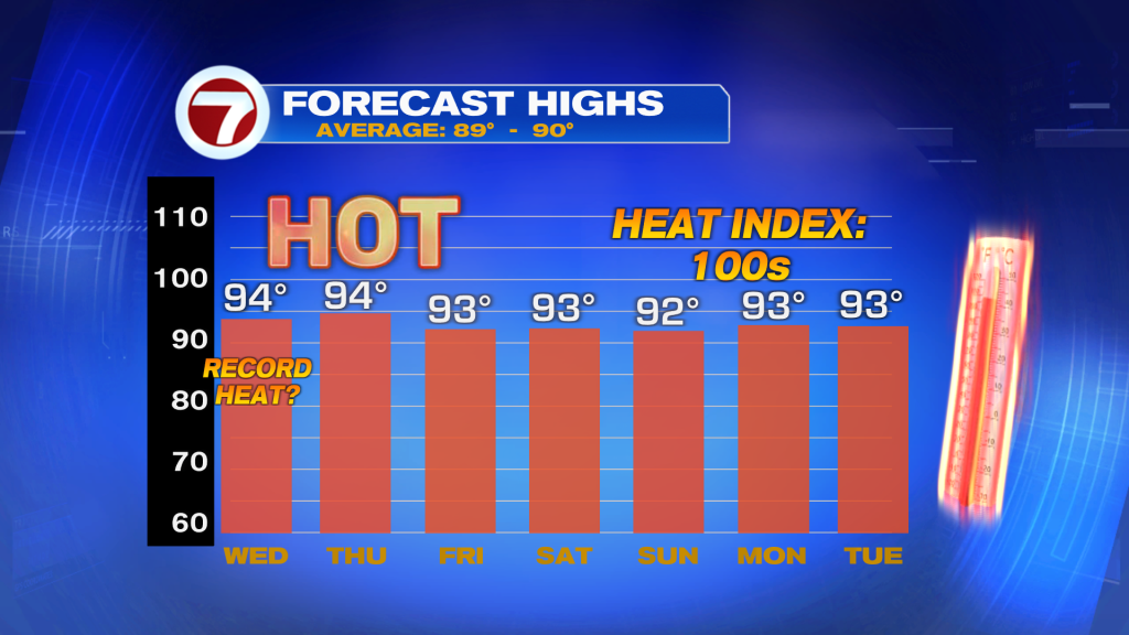
A Heat Advisory is in effect from Noon to 6 pm for Miami-Dade and Broward counties as heat index values climb between 104 and 108 degrees. High temperatures will reach the low to mid 90’s, while tropical humidity makes it feel much hotter. Residents are encouraged to stay hydrated, take frequent breaks if working outdoors, and limit strenuous activities during the hottest part of the day.
Scattered storms are expected to develop this afternoon and early evening, with the greatest coverage across Broward and Palm Beach counties. Some storms could produce heavy downpours, gusty winds, and frequent lightning. Isolated areas of street flooding will be possible where storms linger.
Another concern today is smoke from the Quarry 2 and Well Fires burning in Western Miami-Dade. Southerly winds will continue pushing smoke North and Northeast, creating hazy skies and potentially reducing air quality across portions of Miami-Dade and Broward. Sensitive groups, including those with respiratory conditions, should monitor air quality and limit prolonged outdoor exposure if smoke becomes noticeable.
Looking ahead, South Florida remains in a typical Summer pattern through the rest of the week with daily afternoon storms, above-average temperatures, and heat index values reaching 105 degrees or higher.
Tropics Update
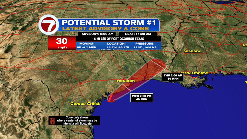
Potential Storm One continues moving along the Texas coast and could still become the first named storm of the Atlantic hurricane season later today. Tropical Storm Warnings remain in effect for portions of Texas and Louisiana.
Regardless of development, the main concern is for significant flooding rainfall, with widespread totals of 5 to 10 inches and isolated amounts approaching 20 inches possible from Texas into Louisiana and portions of the central Gulf Coast.
Have a wonderful day South Florida and make it a safe one!
Vivian Gonzalez
Meteorologist, AMS Certified
WSVN Channel 7