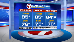
We are now 49 days into the year and today was the warmest one for south Florida! Nearly all the reporting stations were showing afternoon highs in the middle 80’s making for the warmest day since last December 4th. By the way, record highs were recorded in the Middle and Lower Keys. Marathon soared to 88 degrees (third day in a row with a record high)! Additionally, Key West tied the record for the date, at 84-degrees.

There’s more springlike warmth ahead, too. The Tuesday weather map shows a weak front draped over Florida and we’re on the warm side of it. North of that boundary, there happens to be milder air with lower humidity, but it won’t be able to reach south Florida. The front will actually lift back up (near the Gulf) while the eastern part of it fades out over the Atlantic Ocean.

Our weather will be virtually be unchanged as the week continues. The reason? High pressure is stacked well up into the atmosphere. That’s setting up an extra-sturdy roadblock for any posing systems. Basically (to continue with the roadblock analogy) storm motion is bypassing our region with a detour over the Florida peninsula and into the southeast (and mid-south states).

Air conditioners will continue to be necessary as we stay in the 80’s during the day and 70’s at night. Here’s a look at the persistence of the warm days ahead.
