A shift in winds and we’re suddenly warm again, south Florida! Thursday highs elevated well into the 80’s and Marathon even tied a record high for the date (at 89-degrees).

The warmth grew despite the fact that more clouds were streaming across the region. Here’s the late day view along Biscayne Bay with mostly cloudy skies.

As we head into the long holiday weekend, there’s a real focus on the radar. More rain is likely to expand across Florida, courtesy of moisture arriving from the tropics (southerly air flow). That’s set to merge with a cold front that’s swiftly heading into our state from the north and west.

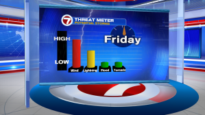
On Good Friday, there’s a threat of strong storms. The greatest risk from these will be from gusty winds. Lightning is also a valid concern with a lower (but still possible) risk of tornadoes and waterspouts.
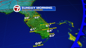
The front is expected to pass south Florida early Saturday with gradual clearing and drying. Then, a brief turn in winds (temporarily out of the northwest) will allow for some cooling into Easter morning. At sunrise, temperatures will be in the lower to middle 60’s. That’s at least 5-degrees below average for this point in April.