We expect high levels of heat in late June, but south Florida temperatures are really sizzling this weekend! Here’s a look at the official highs from Saturday. Beyond these impressive numbers, the “feels like” temperature was over 100-degrees throughout the afternoon. That’s the heat index measurement (when humidity is factored-in) and it will be similar on Sunday.

High cirrus clouds can be seen drifting across central and south Florida, late in the day. Overall, Florida remains mostly dry.

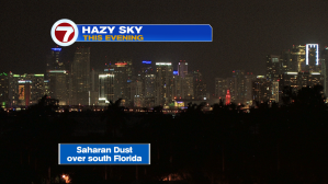
There’s also a noticeable amount of haze over us. Here’s a recent Miami view. This is due to the northern fringe of some Saharan Dust particles. It happens, occasionally, as dust remains suspended in the air all the way across the Atlantic Ocean. There’s actually a thicker area of Saharan Dust over the Caribbean Sea right now.
Heading into Sunday afternoon we’ll be watching the soaring temperatures, once again. There’s a decent chance that Miami will match (if not exceed) the record high for the date, as shown!

Looking beyond Sunday, the forecast calls for temperatures to settle back, slightly. While it will remain hot, it may be more tolerable due to a breeze off the ocean. Also, more daytime clouds with occasional showers will help bring some relief from extreme-type heat.
