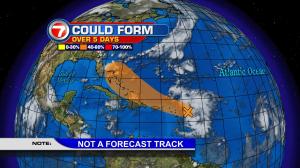
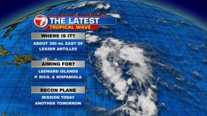
There’s currently 1 classified tropical weather system, and it’s not a threat to land. Here’s the latest on Tropical Storm Gaston (followed by another area in the tropics that’s more important for “people and land”). Gaston is in the eastern Atlantic Ocean and it’s already a strong storm. Wind speeds aren’t that far from hurricane strength and it’s forecast to become a hurricane over the open ocean waters. As the week continues, the spot in the tropics that’s necessary to follow (all the way from the Caribbean islands to Florida, then the east coast of the United States) is now approaching the Lesser Antilles. It’s a large tropical wave, for now. There’s real potential for it to get stronger during the second half of the week. Eventually, it could shift from the Caribbean island chain toward the Bahamas. We simply need to watch it, and while we wait? We should monitor the future health of the system. As many of you know, and as we’re reporting, some of the long range models have the disturbance heading “close” to Florida from the weekend into early next week. For now, it’s just too early to predict with any certainty, since a circulation center hasn’t been located yet.