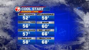
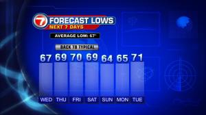
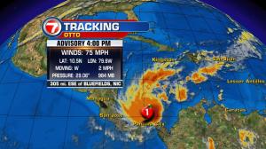
We’ve had some cooling recently, but it’s moving out. Temperatures are returning to normal levels and the trend will hold through the Thanksgiving holiday. Why have we been going through these weather changes? Several cold fronts were crossing the region, but it wasn’t until Sunday night that we experienced a stronger frontal passage. Widespread lows in the 50’s were spanning the area on both Monday and Tuesday mornings. As a whole, that’s as cool as we’ve been in exactly 8 months! The cooling wasn’t to last much after the passage of the front. High pressure started to return, sending winds off the ocean (and thus, ushering in a milder weather pattern). Expect plenty of comfortable air for Thanksgiving. Basically, it won’t be “too warm” during the day or “too cool” at night. If you’re going to be near the coast, or at the beach, you’ll detect stronger winds arriving from the east. The only deviation in the weather pattern will be a minor one at the start of the weekend. That’s when another cold front is likely to move into south Florida. At this point, it doesn’t appear as though the front will have much moisture to work with (so rain chances stay quite low). As for cooling potential, it won’t have much of that either. Temperatures will only fall, in slight fashion. Then, by next week, more seasonal warmth will build again. Finally, there’s activity in the tropics. Newly formed Otto has been getting stronger in the southernmost Caribbean. On Tuesday, it even became a rare November hurricane! Furthermore, it’s made it into the record books. Hurricane Otto originated at the latest date for a hurricane to form in the Caribbean Sea. Later this week, it will make landfall near the Costa Rica and Nicaragua border.