With “in and out” clouds, we’ve had a beautiful start to the week with an increasing breeze. On Tuesday, winds made for a comfortably warm day with highs in the middle 80’s. Unfortunately, the onshore winds created a rip current danger at the beach, so swimming wasn’t advised.

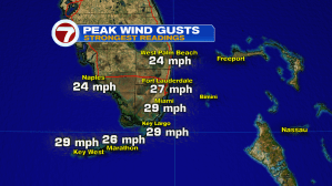
From the Florida Keys and all along the southeast coast, wind gusts peaked close to 30 miles per hour.
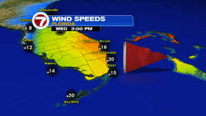
Sturdy ocean winds can be expected again on Wednesday with gusts similar to Tuesday (if not higher).
There’s a stream of moisture that should head our way, especially into Thursday and Friday. The moist air surge will come around the base of distant high pressure (over the western Atlantic). A disturbance currently over the southeastern Bahamas may also trigger a few thunderstorms during the late week time frame.
