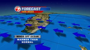
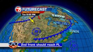
Christmas 2016 is now in the books, the weather record books, that is! Miami reached a high of 85 degrees on Christmas Day which matched the warmest December 25th since official records have been kept. The warm weather will hang around through the first half of the week and then scale back by the weekend. Along with higher than normal temperatures, we’re also experiencing winds that are especially strong. You’ll notice a gusty breeze near the coast. These onshore winds will cause dangerous swimming conditions area beaches… due to strong rip currents. Meanwhile, rough seas will lead to some boating hazards at least through Tuesday. Looking ahead, the next weather change involves a distant cold front. The boundary is expected to reach south Florida early on Friday. It won’t be much of a rain maker (many fronts tend to lift the air and trigger rain) but it should have cool air support. Will jackets be needed? That will depend on your threshold for “cooler” weather in our often tropical climate. As temperatures drop about 10 degrees, nighttime lows could dip to 60° or so, by the start of the weekend. Long range forecast maps show the cold front sliding south all the way to Cuba. Don’t take this as gospel though. It’s still a long way off and things could change. We’ll be hoping the front doesn’t decide to stall out over the region. That would spell cloudy and muggy conditions for New Year’s Eve. At this point, our forecasts call for mild and comfortably cooler weather for the holiday festivities.