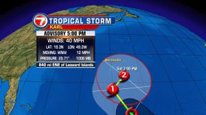
Florida is back to being a stormy kind of state. We’re seeing a higher frequency of storms due to several weather features that can be found on nearly all sides of the peninsula. Because there’s a stalling front to our north (and lots of moisture from the tropics) we’ll continue to stay ripe for heavy rain. The wet pattern may ease later on this week, but until then, developing storms are likely during the afternoons and evenings. Most of our summertime downpours will flare up as the east coast sea breeze tries to move inland. Since moisture is trapped, any rain shower will be capable of a major soaking. Be prepared for the threat of localized street flooding… resulting from the slow progression of activity. In the tropics we’re back to tracking two systems. Both of these is extremely far from any land. First, Tropical Storm Karl is moving across the central Atlantic. It remains “in check” due to some dry air and wind shear. As it continues to move west (and northwest) it will enter more favorable territory for steady strengthening. Karl isn’t expected to impact any land areas other than Bermuda, perhaps. Well behind Karl is brand new Tropical Depression Thirteen. The depression is already near storm strength. If it obtains a name, the next one on the list is Lisa. Similar to its predecessor, this second system is expected only be a worry for the shipping lanes in the distant Atlantic.