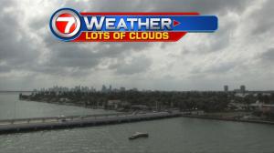
Our weather isn’t looking as bright as it did earlier in the week. Instead of being under a big umbrella of sunshine, you may need to use one, from time to time! Persistent clouds have been streaming over south Florida from both the south and east. Then, once you get north of Lake Okeechobee, the air is considerably drier and nearly cloud free! Basically, there’s a much stronger influence of high pressure impacting the northern two thirds of Florida. Worth noting, there’s also a significant pressure difference in the opposite direction (southward into the Caribbean). As a result, winds continue to be a big weather player for us. Gusty conditions will keep producing hazards along local waters. Boating hazards won’t improve for several days just as rip currents create ongoing issues for swimmers. The long range forecast calls for a bump in rain chances ahead of the upcoming weekend… which is the last one in October. Then, on Sunday, a very weak cold front may “limp” into the area and ease southward. Behind the boundary we should get added drying. However, another wind surge could follow the front providing us with an extra breezy Halloween holiday next Monday (and well beyond)!