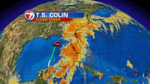

Tropical downpours have been impacting much of Florida. Deep moisture has been drawn out of the tropics, courtesy of Colin (the tropical storm leaving the Gulf of Mexico and moving into north Florida). The brunt of the heavy weather has focused largely from the Gulf into the western peninsula. Torrential rain with rising flood waters have been big concerns during this early week. Coastal waters have also been seriously rough and the strong surf is still posing dangerous conditions for boaters. As the week continues, we’ll see Colin skirt away. The forecast track has the system moving into the western Atlantic followed by steadily weakening. After it departs, does it mean that clear and dry conditions will sweep in, behind it? Not this time. Instead of seeing sturdy high pressure dominating, a cold front will settle into Florida from the north. Unfortunately, that boundary will stall out over the state and result in more wet weather. It’s likely that the front will cause flooding woes (at least in spots) as the week continues. We’ll be hard pressed to get anything but brief sunshine in the days ahead. Expect plenty of clouds and the very humid air to stick around.
