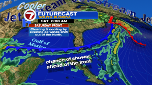
Happy Friday South Florida! The long-awaited cold front that we have been watching the last few days has finally arrived to Northern areas of our Sunshine State! The cold front will finally reach South Florida on Saturday morning but u until it reaches us, a Southwest wind ahead of the front will help temperatures soar into the upper 80s and low 90s (which will round the corner to possibly near-record highs this afternoon).

Showers will be possible Friday overnight into Saturday as the front slowly drifts south across our Sunshine State. Isolated showers and clouds will be likely through the Saturday morning until the front clears our state Saturday afternoon. It’s important to note that Saturday will not be a washout. As the front drifts south, it will slowly lose its punch so moisture will not be as high as we are used to seeing together with a front. Rain chances Saturday morning will remain isolated and then will drop to nothing for a few days after that! Temperatures will still remain warm on Saturday afternoon but then as skies clear by Saturday evening and winds shift out of the North by Saturday night, this will bring in the much-awaited cooler and drier air that we have been waiting for.

Once the cooler and drier air moves in on Sunday, temperatures each afternoon and morning will remain a few degrees below average for this time of year.


Cooler temperatures, together will lower humidity, will definitely be felt, especially after ending the work week with near-record afternoon temperatures.
I know this cooler weather can be distracting but let’s continue to keep an eye on a low pressure system over the Atlantic, which is expected to become our next tropical depression as early as today.

Enjoy your weekend!
Copyright 2024 Sunbeam Television Corp. All rights reserved. This material may not be published, broadcast, rewritten or redistributed.