Happy Saturday, South Florida!
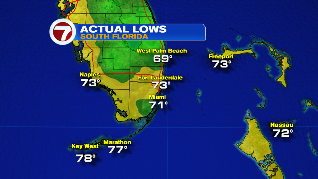
Hopefully everyone has been enjoying the picture perfect weather we have been experiencing the last few days. Low humidity, almost near-average temperatures and beautiful blue skies pretty much sums up our weather through the past week. But we have been hinting at some big changes headed our way for this weekend and this morning we certainly began to feel the difference as we woke up to very mild temperatures across South Florida.
So what can we expect today? Well, the big change will be the steamy temperatures that we are expecting. We got a slight taste of it on Friday afternoon with afternoon temperatures reaching the mid to upper 80s, however, temperatures today will most definitely be warmer than what we felt on Friday. After starting the morning off in the low to mid 70s, our afternoon high temperatures will be reaching into the lower 90s across many South Florida locations. And with the current record in Miami sitting at 91°, Miami along with many other locations, will be flirting with near record heat today. And as far as rain is concerned, that will remain out of the forecast today again.

So why will it be so hot across South Florida? Well for one, a high-pressure system will continue to act as a road blocker from allowing any storm systems or moisture to reach our area through much of the weekend. But with the placement of the high pressure system and with a series of fronts that will remain across the north Florida area, our wind pattern will remain out of the Southwest through the weekend. And as we are all too familiar with here in South Florida, a Southwest wind together with dry conditions usually means one thing: a steamy setup!
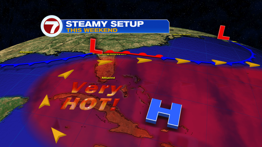
So if lower 90s are a bit too warm for you, then you may not like what Sunday is to bring this weekend. Unfortunately for those who don’t enjoy the heat, that is pretty much what this weekend has to offer us! Today is expected to be on the steamy side while Sunday brings very hot conditions. Our afternoon high temperatures on Sunday will once again reach the 90s, however, models are hinting that they will be even warmer than today. Many South Florida locations will be soaring into the mid 90s by Sunday afternoon while the dry streak continues. And once again many locations down here will be flirting with record high temperatures.

That high-pressure system finally begins to break down as we head into the work week, however, a series of fronts will push through Northern sections of our state but will not be strong enough to clear South Florida. So while models suggest that some moisture does return to the forecast starting Monday, a Southwest wind will remain in place and so will our warm to steamy temperatures through at least a good chunk of the upcoming work week. Of course with cloud cover and a few showers in the forecast, afternoon temperatures next week will be in the upper 80s and lower 90s instead of the mid 90s. But there is a light at the end of the tunnel. There is a front that looks to have a chance at clearing South Florida by the end of next week. If it does so, then South Florida will finally see some heat relief. We will have to see how it all plays out! In the meantime enjoy your weekend, drink plenty of water and don’t forget that sunblock!

Have a great day!
Erika Delgado
Meteorologist
WSVN Channel 7 News
Copyright 2024 Sunbeam Television Corp. All rights reserved. This material may not be published, broadcast, rewritten or redistributed.