This weekend will bring us some important dates for us in South Florida.

We reached the peak of hurricane activity for the entire Atlantic Basin back in September, but the peak for South Florida is Saturday. After that, activity takes a nose dive and as of this moment there is nothing brewing in the Caribbean, Gulf of Mexico, nor Atlantic.
In the Sky

Another important date, is the peak of the Orionid Meteor Shower this weekend. Unfortunately, they will be too low in the horizon and with an almost full moon, they will be hard to spot. If you feel adventurous, make sure to go to a place away from city lights and look southeast. You may get to see about 3 per hour.
The Keys are Sizzling

 On Friday, Key West came within one degree of tying the record for the date.
Since the start of the month, they’ve been within a degree of tying the record highs on half the days. On Wednesday a record was actually tied. But warm temps, a beautiful ocean, and a mild breeze is what the Keys are all about.
Cold vs Hot
Across the Nation, cool air is moving south and running into warm and moist air. Where they meet, strong thunderstorms are firing.


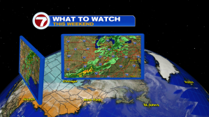 The clash is causing huge downpours from Texas through Arkansas and into the Mississippi River Valley.
The heavy rain continues north into the Ohio River Valley and into the Great Lakes Region. All the rain will aim for the Northeast over the weekend.
The Jet Stream
Some of that cool air could make it to South Florida if the Jet Stream can give it a nudge.

Weekend Forecast
The Jet Stream, which is a river of strong air in the upper levels of the atmosphere, will slide off the Eastern Seaboard by Sunday. It promises to give the cool air a small kick that just may reach our area.

If it does, expect the temps to come down a few degrees. Not a lot but with the temps in the upper 80’s to near 90 of late… it will feel very nice.
