Happy Wednesday, South Florida!
After breaking several records and weeks of warm temperatures in the 80s, a cold front that cleared South Florida Tuesday afternoon changed all of that. And after a chilly start to our Wednesday, that cool change continues tonight!


Northerly winds have continued to pump cool and dry air across all of Florida. And after starting the day off with temperatures in the 50s, afternoon temperatures Wednesday struggled to reach that 70-degree mark. This was a shock to our system, especially after being in the 80s for 19 days!
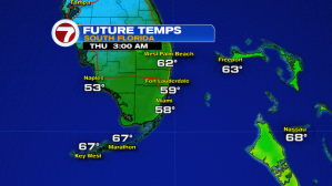
The cooler air will stick around for 1 more night with all of South Florida waking up in the 50s once again on Thursday morning, with the exception of the Keys where temperatures Thursday morning will be in the mid to low 60s.


While Thursday is expected to be a touch warmer than Wednesday, afternoon high temperatures will still remain below average for this time of year.


Winds will slowly shift out of the East Thursday into Friday and this will help trigger a warming trend across all of south Florida. And just like that….as quickly as the cooler air arrived, it will move on just as quickly. And while the next 5-7 days are looking mainly dry, with the return of an ocean breeze on Friday, temperatures will not only begin to warm again but moisture slowly creeps back into the forecast. This means we could see a spotty shower or two as early as Friday.


So let’s enjoy this refreshing change in the air for 1 more day. Steamy temperatures in the mid 80s are set to return to the forecast by the upcoming weekend!
Erika Delgado
Weekend Meteorologist
WSVN-7 News
Copyright 2024 Sunbeam Television Corp. All rights reserved. This material may not be published, broadcast, rewritten or redistributed.