Florida has been dealing with days of storms firing up. Wednesday was no different with more activity over northern and central parts of the state. While not necessarily quiet over south Florida, storms were more scattered and in a limited path from southwest to northeast. A good portion of northern Broward County even had some strong storms and severe weather alerts.

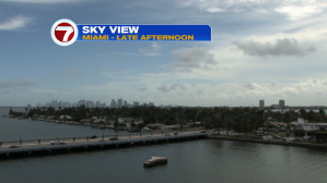
Here’s a look at the sky over downtown Miami (Wednesday afternoon). The main difference through the day was an increase in high level cloudiness.
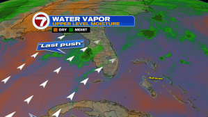
The soggy and stormy weather pattern, dominant for nearly a week, is finally about to change. This transition is probably best depicted from the water vapor imagery. The map shows what we’ll call the “last push” of deep moisture into Florida. Throughout the early part of the week, there was a huge shield of tropical moisture setting us up for heavy rainfall. Finally, the vapor map shows that from the southwest (upper steering flow) there’s drier air on the approach.
With the late week drying, we’ll also see stronger sunshine and hotter temperatures. The best chance for record highs on Thursday will in the Florida Keys.

The hotter weather “connection” arrives into Florida with persistent light winds out of the south.

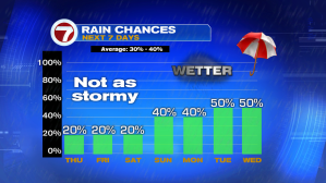
Here’s a check on rain chances which are much lower as we round out the week. Next week, then, we’ll revert back to more seasonal storms.
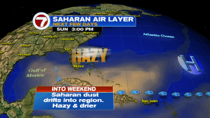
You may notice a layer of haze over skies in the days ahead. It’s part of a pattern occasionally seen this time of the year, related to Saharan Dust. The set up should begin on Thursday and last well into the upcoming weekend. It will bring beautiful sunsets while giving the sky a milky appearance. Unfortunately, it also brings a hazard. Some people may be sensitive to the dusty air, especially those with respiratory issues. It could become necessary to stay indoors (in the air conditioning) in order to avoid the Saharan dust.