We begin with a Major Hurricane impacting Western Mexico, as a category three with winds in excess of 111 mph. Its name is Willa, and it will dump plenty of rain in its path across Central Mexico. On Thursday the system should come to an end, but the moisture associated with it will push on into the Gulf.

Once there, it will get absorbed by another Low just to the Southeast of Texas.
Front on the Move

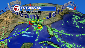
The low will drag the moisture and a Front to the East. South Florida will remain mild with typical temps through Thursday. We may see an isolated shower off the breeze. In the long run, the front is expected to move across South Florida.

It will get a big push from the jet stream, which is a huge river of strong air in the upper levels of the atmosphere, arriving sometime on Saturday. It could bring us a few showers and then slightly cooler temps.
Finally Fall

We could finally get a taste of fall, Florida style. Typical temps are in the low to mid 70s, we should see the mid to upper 60s for Sunday, Monday, and Tuesday.
Something else very Seasonal, will return…. King Tides

They are caused from an alignment between, the sun, earth and the moon. This straight line adds an extra pull to the ocean and makes the waters rise even further. When it happens along high tide, these King Tides can cause minor street flooding along coastal communities.

The King Tides are a gradual build up of seawater that impacts low laying areas. This process can take up to 6 hours from start to finish.
Something Stirring in the Tropics

It’s not over ’til it’s over. An area of disturbed weather is making its way across the middle of the Atlantic Ocean. The National Hurricane Center is giving a 40% it can develop in the area highlighted orange over a period of 5 days. Once formed, it should travel west. How far and how strong still remain unknown. We’ll be following it.