We’ll start off the weekend on a bright note. High pressure will keep us nothing short of seasonal for this weekend. Expect mostly to partly sunny skies with isolated showers and inland afternoon/evening storms courtesy of the sea breeze. This will also be the case on Sunday.

By the start of the work week, a surge of deep tropical moisture will bring a double dose of stormy afternoons/evenings on Monday and Tuesday. We’ll return to the seasonal setup of morning sun and inland PM storms for the rest of the week as we usher into the Fall season.
TROPICS
We also still tracking two storms in the tropics, Julia and Karl.

National Hurricane Center is forecasting Julia will weaken on Saturday to a remnant low off the Carolina coast.
Additionally, Tropical Storm Karl is still far from South Florida and moving west in the open Atlantic waters. This storm is not expected to gain intensity this weekend.

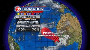
Your storm station is also watching an area of low pressure associated with a tropical wave off the west coast of Africa. It has high chances of developing over the next 5 days. Plenty of time to watch.
Copyright 2024 Sunbeam Television Corp. All rights reserved. This material may not be published, broadcast, rewritten or redistributed.