Happy Thursday, South Florida!
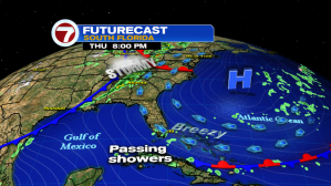
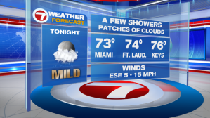
Breezy to gusty winds have kept the flow of clouds and a few stray showers moving through South Florida from time to time. Looks like this could pick up a bit overnight as a disturbance from the Bahamas approaches the Florida Straits.

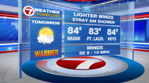
On Friday, winds will begin to die down, triggering a warming trend across all of South Florida.

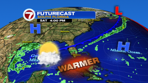
And by Saturday afternoon, afternoon temperatures across all of South Florida will be reaching into the mid 80s again. And while the weekend will start with sizzling temperatures, all eyes will be on an approaching front that will be slowly drifting south across our Sunshine State.
Once that front arrives to South Florida on Sunday, our weekend will go from a warm one to a wet one. And this time around, the wet pattern will outlive the warm pattern! Apart from the showers along Sunday’s front, it looks as if that front will park itself just to the south of us, allowing a few disturbances to ride along it in the following days. That means, Sunday’s rain is only the beginning of what has the potential to be a few unsettled days here in South Florida.


Showers & a few thunderstorms look to stick around through the first half of next week. And with a cold front just south of us, cloudy skies, anytime showers & a brisk breeze,….temperatures will remain on the cooler end each day. We can expect afternoon high temperatures to remain at or just below average for this time of year.
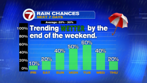

So let’s enjoy these last few warm & dry days we have because on Sunday we will be trading in
the sunglasses for rain gear.
Enjoy the rest of your week!
Erika Delgado
Weekend Meteorologist
WSVN – Channel 7 News
Copyright 2024 Sunbeam Television Corp. All rights reserved. This material may not be published, broadcast, rewritten or redistributed.