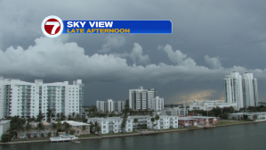
Another wet day targeted parts of south Florida. The stormy times focused on inland areas (almost exclusively) during the middle and late afternoon. Then, the active spots weakened during the evening.
We’re surrounded by plenty of moisture that’s streaming into nearly all corners of the state. Recently, the driest region has included the Florida Keys.

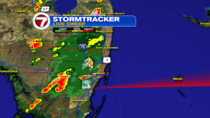
Here’s the radar from the late afternoon. Notice the extent of lightning from the image. Earlier captures included even more flashes of lightning prior to some slight settling.
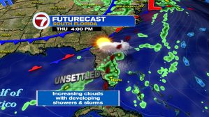
Looking into Thursday, the weather pattern doesn’t deviate much from recent days. Expect plenty of steamy sunshine through the morning with thunderstorms becoming more widespread with the prime heating of the day. Storms could, once again, contain lots of lightning, gusty winds and heavy rainfall. Since the actual wind speeds remain light, areas of rain will slowly (and possibly waywardly) drift around during the late-day.
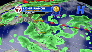
If you’re thinking ahead to the weekend, here’s the updated outlook. The general rain chance remains “likely” but there will be several dry hours, too.

The main weather change for the holiday weekend is that we’ll see a change in wind direction. While that may not seem like a big deal, it will result in differences related to rain and storm “timing”. Instead of unsettled conditions evolving during the afternoon, the focus will be during the morning hours. Damp conditions with isolated storms will pass by early in the day with the steering flow sending the activity away (to the west). Basic improvement can be anticipated and that’s probably better for daytime plans.