The weekend started soggy. How wet? Saturday was our wettest day in south Florida in over a month! Most places picked up over one-half inch of rain (and Pembroke Pines exceeded the 1-inch mark). Fortunately, by the start of the WinterFest Boat Parade in the evening, most of the rain had departed. Since the cold front was able to slide across the mainland and Keys, the majority of lingering showers were bunched up from the Straits to the northwest Bahamas by late Saturday.


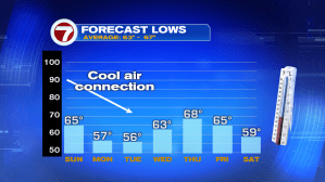
As clouds stubbornly stretch over the region (despite the front crossing) temperatures will remain steady into Sunday morning. Forecast lows will be mild and comfortable across south Florida, but there’s quite a difference in degrees as we look northward.
Gradually, as high pressure builds down with air arriving from the north, we’ll find more cooling filtering our way. Wake up temperature lows both Monday and Tuesday mornings will be in the 50’s as we encounter another “brief cold snap”. Technically, this cool spell isn’t as dramatic as some more recent one’s, going back to late November and earlier this month.