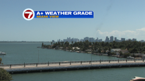
Beautiful weather is back across south Florida. Much of Thursday included a bright blue sky and pleasantly warm temperatures. This was the view during the afternoon.
Early Friday morning could include one weather issue that’s likely to be minor: patchy inland fog. The greatest chance will be across the interior areas of south Florida in the hours leading up to sunrise.
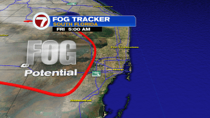
Once the morning fog burns off (quickly Friday morning) expect seasonally warm temperatures that will be slightly higher than recent days. Most afternoon highs, locally, will be in the middle 80’s.

The national weather map shows a large storm across the western Great Lakes with a trailing cold front. As the weekend continues, a secondary storm system will develop along the southern flank of the boundary. Active conditions including a threat for tornadoes will intensify from Saturday through Sunday. The only at-risk area for Florida will be around the panhandle.

The long range forecast map shows a future cold front approaching south Florida into early next week. The front will be weakening considerably and only a few rain bands are expected for our region.
