Happy Sunday, South Florida. After waking up to drier and slightly “cooler” conditions across the Southern half of our Sunshine State yesterday, a returning ocean breeze will help moderate the air mass and has allowed overnight temperatures to remain on the warmer side compared to Saturday morning. Good news is that drier air in the mid-levels of the atmosphere still remains over South Florida.
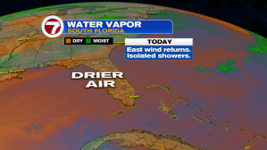

So, similar to what we saw on Saturday, our Sunday is looking mostly quiet with only a few isolated showers in the forecast. As winds shift out of the East later today, any showers that do develop this morning or early afternoon will eventually push out towards the Interior and the West Coast. That means this afternoon will be great for all outdoor activities!

And it looks like that drier weather pattern sticks around for a little bit! The rainy season officially ends this upcoming Monday, October 15th and while temperatures are expected to remain on the warm side, the rain forecast for the upcoming work week surely reflects the start of the dry season.


As South Florida slowly transitions to a more Fall-like weather pattern in the days to come, the Tropics are beginning to settle down. Leslie finally made landfall in Portugal Saturday evening, bringing violent winds, and more than 5″ of rain in that area.

So now that Leslie is finally gone and we are finally over the hump from peak hurricane season, we are only keeping an eye on 1 system over the Atlantic (and that system has a very low chance for development in the days to come).

Now that’s something to celebrate!
Enjoy your Sunday, South Florida. Will be a beautiful one!
Copyright 2024 Sunbeam Television Corp. All rights reserved. This material may not be published, broadcast, rewritten or redistributed.