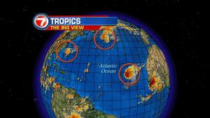
Add Karl to the list. The newly formed tropical storm formed late Thursday night. It’s the season’s eleventh named tropical system. It’s worth noting that (for at least the moment) Karl is joined by two others… spanning across thousands of miles of open ocean waters. In the western Atlantic, Tropical Storm Julia continues to spin (a couple hundred miles offshore from South Carolina). Next, Ian is moving into the north central Atlantic where it will lose tropical characteristics on Friday. Karl, meanwhile, was upgraded from a depression near the Cape Verde Islands… not too far from Africa. Since Tropical Storm Karl is more than 3 thousand five hundred miles from the United States, there’s a long time ahead to follow the feature! It’s moving westward at 15 miles per hour and the National Hurricane Center is forecasting Karl to maintain storm strength over the next few days. By the middle of next week, we’ll see if it comes close to the Leeward Islands. Until then, there’s nothing but open water in sight. Our south Florida weather remains status quo. Mainly inland storms… the scattered kind… will flare up during the afternoon hours. It’s the result of sea breeze instability and active circulations in the air. At the same time, there’s plenty of heat and thick humidity. This classic summer weather will continue into the upcoming weekend. By the way, the official start of fall is just 1 week away!