Be sure to keep that rain gear with you today!
After a soggy start to our Saturday morning, rain showers will continue on & off through much of the day today. Tropical moisture moving in from the Caribbean will keep skies looking grey today while rain chances remain high for much of the weekend. All of South Florida will see the rain continuing on & off today but the heaviest of the rain will be found the farther south you go. That means the Keys will see the best chances for rain.


Today South Florida can expect limited, if any, sunshine with a good chance of rain showers. The breeze will also remain on the stronger side with some spots windy to gusty at times.


And with the steady amounts of rain expected, street flooding could eventually becoming a problem across already flood-prone areas, especially because rain will continue to move through across some South Florida spots on Sunday. (Again, the Keys looking like the wettest areas of South Florida).

Conditions slowly begin to improve for the start of the work week, which also happens to be the first day of Fall! After a few showers on Monday, lower humidity finally arrives and even though temperatures will remain near or just below average, it will actually FEEL like Fall. So at least there’s a light at the end of the tunnel. Once we get through this wet weekend, South Florida will finally enjoy a few nice days of weather.


And while Fall is just around the corner, the Tropics remain quite active. Tropical Storm Jerry remains a little over 700 miles South of Bermuda. And while Jerry is not expected to be a threat to the Bahamas or the United States, Bermuda does remain in harm’s way and could be dealing with a category 1 hurricane by the middle of the upcoming work week.


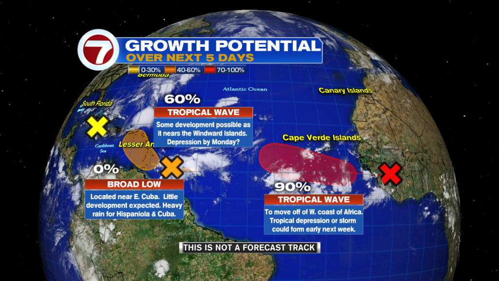
Elsewhere in the Tropics, we are watching three different systems across the Atlantic & Caribbean Seas. A low pressure system near the Eastern tip of Cuba is has a low chance of developing. And while little development is expected, heavy rain is likely across the island of Hispaniola, Jamaica & Cuba. Closer to the Windward Islands we find a tropical wave that is moving quickly towards the West. And while this system is not looking organized, conditions are becoming a bit more favorable for development and a tropical depression could form early next week as it gets near the Windward Islands. Farther East,…a tropical wave is forecast to move off of the West Coast of Africa. This system has a very high development chance in the next few days and we could be dealing with a tropical depression or even a tropical storm by the upcoming work week.
Remember to keep that rain gear with you today!
Erika Delgado
Meteorologist
WSVN Channel 7 News
Copyright 2024 Sunbeam Television Corp. All rights reserved. This material may not be published, broadcast, rewritten or redistributed.