As I was writing this, I thought about how I’ve had a stretch of 7 straight work days, and how nice it will be to kick back on Sunday and read the newspaper. I know it’s old fashioned, but there’s something about it I enjoy. I don’t get it on a regular basis because I like trees and dislike the pollution that comes with it but every once in a while, it’s a guilty pleasure. But I digress….
We are entering a soggy pattern

Tropical moisture has been hanging across South Florida, and Sunday will be no different. The only question is, where exactly will the downpours set up. Some models suggest the Everglades and others dump it right over us. I will keep my umbrella handy just in case the later is correct.
By the start of next week, even more rain is expected, and if a low organizes in the northeastern Gulf of Mexico, the chance for downpours may have to go higher for the end of the work week.
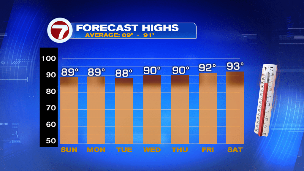
The scattered showers and storms will keep our temps more or less where they should be. We can enjoy a few days without temps in the mid 90s. Unfortunately it will be steamy and humid so it may not feel any less hot.
Trouble in the Tropics?

As of Saturday afternoon, The National Hurricane Center was looking to the nation’s midsection for possible tropical development down the road. They think a front coming out of the Kentucky/ Tennessee area, may spin up a low as it gets into the northeastern Gulf of Mexico. Once there, NHC gives it a 20% chance to become a depression or a storm over a 5 day period. If it does organize, it may do it in the area highlighted in yellow.
Anything else?

Outside of the possible low, there are 4 waves we are following but Saharan Dust is keeping most of them at bay. Only one in the Central Caribbean has some storminess with it. It will continue moving west possibly dumping some rain across Jamaica and Eastern Cuba before moving onshore Nicaragua.
We’ll keep you posted.