Happy Sunday, South Florida!
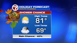
Last week’s cold front left the first noticeable cooldown of the season. And those cool-ish temperatures stuck around for the start of the weekend. But with high pressure in control, more sunshine & winds shifting a bit more out of the East today, temperatures have already begun to rebound. And that was evident this morning where temperatures across our Sunshine State were anywhere between 5-10 degrees warmer than yesterday morning.


While temperatures continue to rebound & the air mass becoming more humid, a disturbance over the Gulf of Mexico also helped kick up a few showers and thunderstorms across the Florida Straits this morning. So showers remain in the forecast for the Keys today with an isolated shower or two possible for the rest of South Florida.
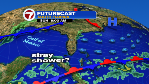
Come Sunday into Monday, the stubborn clouds will finally begin to burn off. Increasing sunshine and wind off the water means temperatures will assist in the warming trend through the start of the upcoming work week. Come Monday, some South Florida spots could even reach the mid 80s.

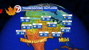
And speaking of next week…Thanksgiving is right around the corner! Here in South Florida, we are keeping an eye on the potential for a storm system to develop over the Gulf of Mexico by the middle of next week. If it develops, then rain and possibly thunderstorm chances could possibly go up for Thanksgiving Thursday and Black Friday. Elsewhere across the country, temperatures on Thanksgiving will be on the cooler side for our friends in the New England area.
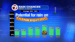
But with Thanksgiving still 5 days away, let’s focus on the dry weather pattern that continues through the start of the work week. Here are the rain chances for the rest of the week:
ENJOY THE REST OF YOUR WEEKEND!
Erika Delgado
Weekend Meteorologist – WSVN7
Copyright 2024 Sunbeam Television Corp. All rights reserved. This material may not be published, broadcast, rewritten or redistributed.