Happy Sunday, South Florida!
High pressure over the Atlantic waters will begin to break down today and lift North. This will allow for tropical moisture to slowly move into South Florida. This will allow more clouds in the forecast today and higher rain chances starting this evening.
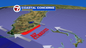
Rip currents continue to be a big issue along Atlantic beaches today. Winds will be out of the East up to 15-20mph while winds could be gusting as high as 25 mph at times. Marine conditions over the Atlantic & Bay waters will remain hazardous. Small craft advisory is in effect for the Miami-Dade, Broward and Keys nearshore waters.
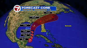
As we start the work week, all eyes are on the tropics as we could see more tropical moisture associated with Tropical Depression 14 (just a few hundred miles SSW of Western Cuba).

Tropical Depression 14 is expected to strengthen and is forecast to become Tropical Storm Michael today as it continues to drift towards the North. Once T.D. 14 moves over warmer Gulf of Mexico waters, it is currently forecast to strengthen into a hurricane. Direct impacts to South Florida are NOT expected. Its latest forecast track keeps TD 14 West of South Florida.
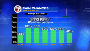
While TD 14 is expected to “miss” South Florida, we will be on the “wet” side of the storm so expect heavy rain, thunderstorms and gusty winds to linger throughout much of the upcoming work week. Monday and Tuesday are looking quite cloudy with pockets of heavy rain and thunderstorms encompassing much of South Florida.

Let’s keep a close eye on the Tropics in the days to come. While Tropical Depression 14 remains west of South Florida, the heavy rain could cause flooding in flood-prone areas.
Have a great Sunday