Happy Sunday, South Florida!
Winter warmth has taken over much of our Sunshine State. South Florida has been feeling that sizzle the last few days with temperatures each afternoon reaching well into the mid 80s. Some areas down in the Keys even managed to warm into the upper 80s, breaking several records this weekend.


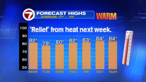
While Sunday afternoon proved to be warmer than previous days, the weather pattern will finally change for a few days with the approach of a weak front. A cold front that was responsible for flooding rain across the Tennessee Valley & triggering strong to severe thunderstorms across the Southeastern U.S., will finally reach South Florida on Monday. And while a significant cool-down is not expected, the cloud cover, showers & winds shifting out of the ENE will be enough to knock temperatures down a few degrees – bringing afternoon temperatures closer to near seasonal.


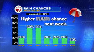
While the work week starts off on the quiet side, rain & cloud cover return to the forecast by Tuesday & looks to stick around through the middle of the week….And that will help keep temperatures in the lower 80s each afternoon (which will feel much nicer than the mid to upper 80s that we have been feeling all week!)

So let’s enjoy the dry & warm conditions to start the work week. You’ll be grabbing that rain gear by Tuesday!
Have a great last week of February!
Erika Delgado
Weekend Morning Meteorologist
WSVN-7 News
Copyright 2024 Sunbeam Television Corp. All rights reserved. This material may not be published, broadcast, rewritten or redistributed.