Happy Thursday, South Florida!
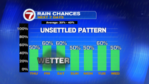
It hasn’t been the best week for South Florida. It has been a wet week so far and it looks like conditions heading into the weekend will remain on the soggy side.
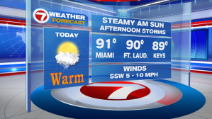
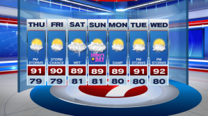
Mild & muggy conditions this morning will give way to a steamy & stormy afternoon. A Southwest steering flow, together with steamy AM sunshine we saw, will help thunderstorms quickly develop this afternoon and push towards the East Coast. And while temperatures will remain in the mid to low 90s, heat indices across South Florida will reach the upper 90s and low 100s later today! Needless to say keeping hydrated this afternoon will be very important.
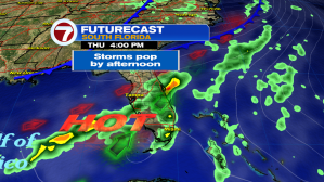


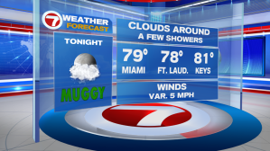
The Storm Prediction Center has placed South Florida East Coast under a marginal risk of severe thunderstorms this afternoon, which shouldn’t be of surprise as every day thunderstorms in South Florida have the tendency of quickly turning severe. Main impacts with any severe storm later today would be FREQUENT LIGHTNING, LARGE HAIL, STRONG WIND GUSTS, HEAVY RAIN & of course we cannot rule out ISOLATED TORNADOES. So let’s keep an eye to the sky today. Showers & thunderstorms could linger into the evening hours.

Rain & thunderstorm chances stick around through the upcoming weekend. The return of an ocean breeze should help afternoon temperature moderate to near-seasonal. Unfortunately, while temperatures become a bit more tolerable, it looks like tropical moisture makes its way back into the forecast for the upcoming weekend.
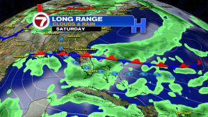
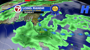
And speaking of this weekend….it’s Father’s Day! Showers & thunderstorms will be a big part of the forecast for Dad’s weekend so be sure to plan accordingly and have that umbrella with you at all times.

Remember to keep that rain gear with you through the rest of the week!
Erika Delgado
Weekend Meteorologist
WSVN Channel 7 News
Copyright 2024 Sunbeam Television Corp. All rights reserved. This material may not be published, broadcast, rewritten or redistributed.