Happy first weekend of December, South Florida!
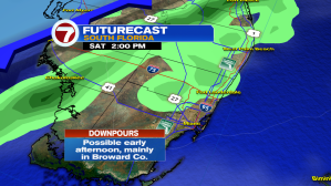
Pesky clouds that have been streaming in from the Gulf of Mexico look to stick around for much of your Saturday. And while we can expect mostly cloudy skies today, South Florida could see peeks of sunshine as we head into the afternoon. This will help temperatures across some spots reach the mid to low 80s this afternoon. Otherwise high pressure over the Atlantic continues to dominate the weather across our area.

A Southeast wind will be on the stronger side today, which has already kicked up seas a bit. Smaller vessels should use caution today for Miami-Dade, Broward & Keys nearshore waters. Also worth mentioning – beachgoers should beware of rip currents along Atlantic beaches.


As we head into the latter part of our weekend, that high pressure system will continue to slide East, allowing the wind to veer out of the South. This will not allow allow temperatures to continue to warm Sunday & Monday but will also help moisture creep back into the forecast.


While the warming trend continues through Tuesday, a cold front is forecast to help knock those temperatures down again. It looks like temperatures through the second half of next week could drop to below average for all of South Florida. And while the cooldown won’t be as significant as the last one, any cool change is most definitely welcomed.


Enjoy your weekend!
Copyright 2024 Sunbeam Television Corp. All rights reserved. This material may not be published, broadcast, rewritten or redistributed.