Happy Sunday, South Florida!
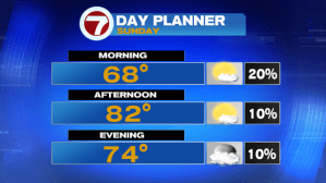
The latter part of our weekend looks to be a warmer one. High pressure will begin to break down causing winds to slowly die down as they shift out of the South and Southwest by this afternoon. This will allow afternoon temperatures to reach into the 80s once again. Any showers today will be spotty along the coast and should dry out by the afternoon.
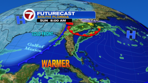

But this weekend’s warm-up will be short-lived! A storm system currently dumping heavy snow across the Midwest & the nation’s midsection is currently dragging a cold front that is forecast to reach South Florida on Monday morning. So as soon as that cold front clears our area, winds will quickly shift out of the North, allowing for the cool air mass to move in.

The difference between this cooldown is that this time around, the cooler weather sticks around for a few days. We’re talking morning temperatures in the 50s on Tuesday, Wednesday AND Thursday, where afternoon high temperatures each day will struggle to even reach the mid 70s all work week long!


So let’s enjoy the quick weekend warmup & be sure to keep those jackets nearby….we will be needing them very soon!
Have a safe weekend!
Erika Delgado
Weekend Morning Meteorologist
WSVN-7 News
Copyright 2024 Sunbeam Television Corp. All rights reserved. This material may not be published, broadcast, rewritten or redistributed.