Happy Sunday, South Florida!
After a warm & dry start to the weekend, a strong dome of high pressure will remain anchored Southeast of the Bahamas, which will allow Southerly winds to continue to pump in warm, moist air across South Florida.


As if reaching the low 80s yesterday wasn’t enough, temperatures will be warmer this afternoon. The difference is that humidity will creep back into the forecast & will allow temperatures to feel warmer than the actual temperature reading.


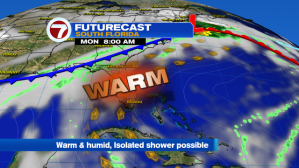
Unfortunately, the warm-up doesn’t end this weekend. South Florida (and much of Florida) will continue to feel the warmth next week. Winds will remain out of the South for the start of the work week so President’s Day is looking JUST as warm (if not warmer!) as the days leading up to it. And this time we could even see an isolated shower or two.


While a few isolated showers are possible on Monday, the surge of moisture that pushes through South Florida to start the work week should be long gone the next day. So expect a warm Tuesday under a mix of sun and clouds. Southeast winds should start to pick up by then.


The rest of the work week will remain warm with low rain chances and steamy afternoon temperatures in the mid 80s. And afternoon temperatures won’t be the only uncomfortable part of the day. Looks like our humid mid to low 70s return to the forecast each morning as well!


So while many of us aren’t ready for the 80s to make a comeback just yet, let’s enjoy the beautiful weather while we can and take advantage of the marine and beach conditions this weekend!


Have a safe long Holiday weekend!
Erika Delgado
Weekend Morning Meteorologist
WSVN-7 News
Copyright 2024 Sunbeam Television Corp. All rights reserved. This material may not be published, broadcast, rewritten or redistributed.