Happy Friday, South Florida!
The weekend is finally here! And while South Florida will see moments of sun, there will be changes headed our way.
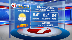
All eyes are on a cold front that is currently across Northern Florida. This front will continue to drift south this weekend and eventually reach us on Sunday. But ahead of it, a Southeast wind will pump in warm moist air from the Atlantic and this will help temperatures warm to the mid 80s each afternoon.

Tonight a warm ocean breeze could drag in a stray shower or two, not to mention patches of clouds moving in from time to time. Temperatures tonight will be a touch warmer than we have seen in a few days. We can thank the Southerly wind component for that!


This trend will continue into Saturday, with isolated showers in the forecast. And by Saturday afternoon, temperatures across all of South Florida will have reached into the mid 80s again.


So with the warm temperatures, many of us will be heading out to the beach for a refreshing dip in the water. Let’s use extra caution this weekend as a breezy Southeast wind will increase the RISK OF RIP CURRENTS along Atlantic beaches.


But while the weekend will start with sizzling temperatures, all eyes will be on the approaching front that we have been patiently awaiting all week long.
Once that front arrives to South Florida on Sunday, our weekend will go from a warm one to a wet one. And this time around, the wet pattern will outlive the warm pattern! Apart from the showers along Sunday’s front, it looks as if that front will park itself just to the south of us, allowing a few disturbances to ride along the boundary the following days. That means, Sunday’s rain is only the beginning of what has the potential to be a few unsettled days here in South Florida.


Showers & a few thunderstorms look to stick around through the first half of next week. And with a cold front just south of us, cloudy skies, anytime showers & a brisk breeze,….temperatures will remain on the cooler end each day. We can expect afternoon high temperatures to remain at or just below average for this time of year….in the mid 70s!


So let’s enjoy these last few warm & dry days we have because once that front arrives, we will be trading in
the sunglasses for rain gear.
Enjoy your weekend & please be safe out there!
Erika Delgado
Weekend Meteorologist
WSVN – Channel 7 News
Copyright 2024 Sunbeam Television Corp. All rights reserved. This material may not be published, broadcast, rewritten or redistributed.