A cold front has been hitting Northern Florida very hard with rain, winds, & lightning since early Friday morning.

Many areas across Central and Northern Florida have been, or still are, under Flood advisories as well as Severe Thunderstorm Watches. The tail end of this stormy mess is aiming for us. Most models are suggesting it will weaken as it approaches the area.
Predicting the timing

The front was expected to start moving into South Florida late on Friday, but it has slowed its forward movement.
If nothing else changes with its forward speed, we may see a few downpours across the area around 4 am, with another batch expected to arrive by 6 am.

With the all important Winterfest Boat Parade taking place on Saturday, the models are calling for some rain across Broward by early afternoon.
These downpours could linger for a few hours accompanied by breezy conditions.
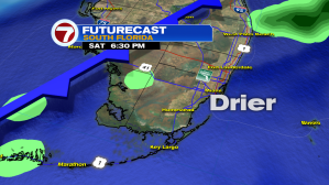
By 6 pm, the front starts to lose most of its moisture and the area begins to dry out. It should remain on the breezy side and temps will slowly start coming down. The sky cover will remain mostly cloudy at least until early Sunday morning when the leading edge of the front exits across the Coastal Waters.

The Keys should see some rain, with heaviest around 11 pm Saturday.
Here too there is a chance for breezy conditions and choppy seas as the front passes over the area.
By early Sunday morning, most of the shower activity has moved away and brighter skies return by around midday.
Cold Front Swings through

By Sunday afternoon the cold front should be over the Northwestern Bahamas with cooler temps entering South Florida, and just like the front having moved in slowly, the same will happen with the cool temps behind it. Every morning it will be a tad colder until Tuesday morning when our lows will be in the 50s.

We’ll be monitoring