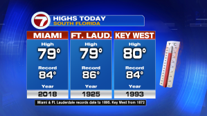
We’re sampling some weather changes. Temperatures are bouncing back (following the most recent cold front, which crossed on Wednesday). Saturday highs were pleasant with a warm breeze coming in from the ocean. By the way, notice here that exactly 1-year ago, Miami was experiencing record warm highs in the middle 80’s!
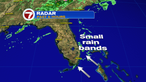
Another change includes some activity on the radar. By Saturday evening, small rain bands were reaching beach locations. Moisture has been on a uptick, as our flow turns out of the southeast. Future showers won’t be lasting long but they could include some brief heavy downpours, in the short term.
On the national weather map, it’s impressive to see the extent of a huge storm system marching from the Midwest through the Mid Atlantic states. Rain, ice and snow have been overspreading the large span of states.

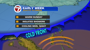
Attached to the storm center is a trailing cold front and it has its eyes set on Florida as the new week begins. We’ll be on the warm side of the boundary Sunday, although that won’t last. The cold front is likely to swing across south Florida Monday morning with cooler air flowing down behind it. Expect the return of low temperatures falling back into the 50’s, beginning Tuesday morning.