Happy Wednesday, South Florida!
Winds out of the East have picked up behind a weak cold front that swung through South Florida on Tuesday evening. Since then it has stalled out just south of us, providing a few gusty spotty showers along the Florida Straits.


As that front weakens and washes out on Thursday, South Florida will remain lodged between that cold front to our South and High Pressure over the Atlantic waters to our North. That means, breezy to gusty conditions will continue overnight tonight and on Thursday.


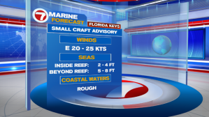
These strong winds will continue to leave dangerous marine conditions for all South Florida near-shore waters. While all small vessels should exercise caution along Miami-Dade & Broward near-shore waters, coastal waters of the Florida Keys have been elevated to advisory level. Not to mention, with Spring Breakers in town, RIP CURRENTS will continue to be a big threat along Atlantic beaches next few days.

Winds will begin to die down by the end of the week, triggering a warming trend across all of South Florida. And by Saturday afternoon, afternoon temperatures across all of South Florida will be reaching into the mid 80s. And while the weekend will start with sizzling temperatures, all eyes will be on an approaching front that will be slowly drifting south across our Sunshine State.


Once that front arrives to South Florida on Sunday, our weekend will go from a warm one to a wet one. And this time around, the wet pattern will outlive the warm pattern! Apart from the showers along Sunday’s front, it looks as if that front will park itself just to the south of us, allowing a few disturbances to ride along it in the following days. That means, Sunday’s rain is only the beginning of what has the potential to be a few unsettled days here in South Florida.

Showers & a few thunderstorms look to stick around through the first half of next week. And with a cold front just south of us, cloudy skies, anytime showers & a brisk breeze,….temperatures will remain on the cooler end each day.


So let’s enjoy these last few warm & dry days we have because on
Sunday we will be trading in the sunglasses for rain gear.
Enjoy the rest of your week!
Erika Delgado
Weekend Meteorologist
WSVN – Channel 7 News
Copyright 2024 Sunbeam Television Corp. All rights reserved. This material may not be published, broadcast, rewritten or redistributed.