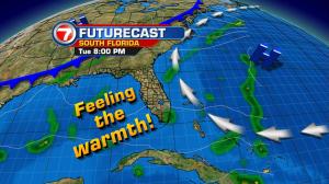
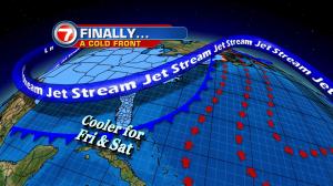
In case you’re counting, we’ve now had 15 consecutive days with highs in the 80’s. That’s quite a streak considering our normal high would have us in the middle 70’s this time of the year! The south Florida forecast still calls for a couple more of these extra warm days… before temperatures settle back to more typical levels. For now, high pressure over the western Atlantic is delivering “ocean air” with onshore winds. The high will begin to break down (slightly) by Tuesday night and Wednesday. As that happens, wind speeds will finally decrease. Meanwhile, by the way, we’ll still have dangerous rip currents at the beach. Also, coastal locations may get more showers off the ocean. Pockets of rain (particularly) impacted the Lower Keys on Monday. A few locations, including Key West, easily racked up the wettest day this December, so far! There’s enough moisture to keep isolated rain batches in the forecast until the next front can drop southward. That would mean status quo weather through Thursday. By Friday morning, a cold front is expected to reach our region. Drier and noticeably cooler air will arrive just in time for the final 2 days of the year! If you’re thinking ahead to New Year’s Eve, I’m including the evening forecast update for Saturday night. I think you’ll like the comfortable conditions expected, along with the low rain chances as we transition into 2017!