As we pause to remember all who have served our great country, Mother Nature will also honor them with nice, albeit, warm weather.
Here’s your 3 day outlook

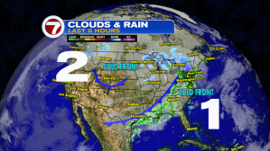
We are watching two fronts, one near North Florida, and the other across the Rockies.
What can we expect?
Unfortunately neither appears to have enough legs to move in.
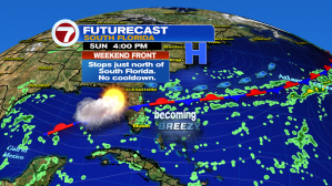
The first, stalls across Lake Okeechobee keeping the cooler air to our north. We remain hot with a slight chance for showers both Saturday and Sunday.
Here are your 7 Day Trends
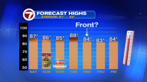
Typical highs for this time of year range between 82° and 83°. We will be well above that through the early part of next week.

The lows may dip into the upper 60s next Thursday, if the second front across the Heartland can muster enough of a push to get here. Even if it does, it should just bring our temps back down to near typical levels.
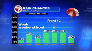
Rain chances also go up a bit for the middle of next week as the secondary front fades across the area.
When can we expect any real cooling?

We need to look at the jet stream for an answer. The jet is like a river of strong wind in the upper levels of the atmosphere. We have two branches, the Sub Tropical and the Polar. The Polar is the most important since it is responsible for pushing cold air our way. We ran our model out for a period of 10 days to see when and if, the Polar jet would bring us some cooler air.
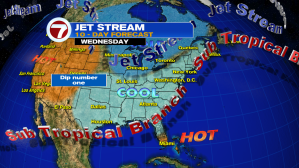
We focus on dips in the Polar Jet.
A huge dip south could drag in some cold air relief. There are two to watch.
The first, barely makes it south of Illinois. This keep the cold air up north.

We don’t see any other dips in the jet until next Monday, when a southward push shows up in the Eastern Pacific. Even if stays this strong and this far south, it may take at least another week for it to get here. Keeping my fingers crossed for a cool-ish Thanksgiving.