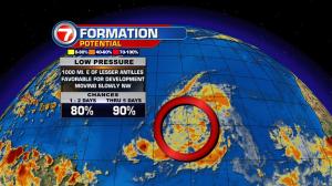
We’re transitioning back into a wetter weather pattern, south Florida. The deepening moisture will continue to expand over the region from the south and east. Interestingly, a distant front will also be stalling north of us (near the Florida state line). Some might say it’s a squeeze play situation that tends to “trap” excess moisture over a large area. We’ll be in good company as areas of rain could surround much of our state, and regional areas, throughout the start of the new week. A minor tropical wave is also being observed. It’s now approaching the southeastern Bahamas. While it’s not heading into favorable territory for development (thankfully) that’s not the number one issue. If the boundary holds and continues to scoot along the prevailing winds, we could see extra strong batches of thunderstorms. The timing for the most active conditions could arrive from late Monday through Wednesday. It’s important to mention that tropical waves are often fragile features. They have been known to fall apart quite easily, as they move from place to place. Still, local rain chances should remain elevated at least due to lingering tropical air. Basically it boils down to this: “persistence, within this pattern” could have us stuck for several days in rainy weather… if features stay sluggish. Stay tuned.