With the heating of the day, the sea breeze will fire up by the afternoon. Expect scattered thunderstorms starting by the late morning hours and sticking around until the early evening over the next few days.
We'll see more clouds building across South Florida today. Expect showers and storms to start during the late morning hours. Anytime downpours could lead to minor street flooding. @wsvn @7weather #flwx pic.twitter.com/T0TD8C1tO3
— Miss Chavis (@karlenechavis) July 10, 2018
A surge of surrounding tropical moisture will get pushed in our direction Tuesday and Wednesday. This will lead to the threat of minor street flooding from anytime downpours over the next couple of days, heaviest west of the turnpike.
The consistent southerly winds will keep morning showers and afternoon storms in the forecast throughout the work week.
TROPICS
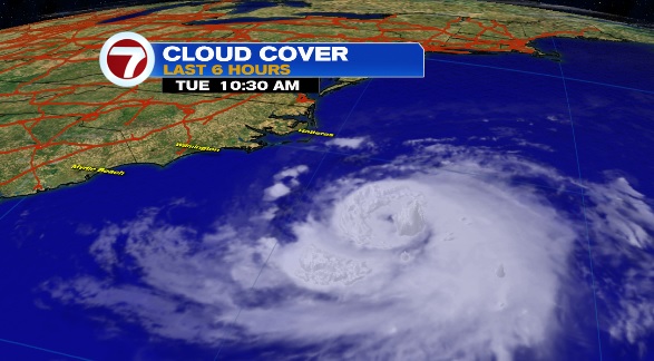
Chris is staying put well offshore from the Carolinas in the western Atlantic waters. This storms is still expected to become a hurricane on Tuesday and swiftly move northeast by the middle of the week.
Dangerous swells and rip currents will remain a threat along the east coast over the next few days.
The remnants of Beryl are producing gusty downpours over Puerto Rico and portions of Hispaniola this morning. These disorganized storms will move northward and over the southeastern Bahamas on Tuesday.
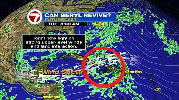
The chance for redevelopment will be low over the next couple of days due to land interaction and strong upper-level winds.
Over the next five days, there is a medium chance for tropical development over the Western Atlantic.

Copyright 2024 Sunbeam Television Corp. All rights reserved. This material may not be published, broadcast, rewritten or redistributed.