Happy Friday, South Florida!
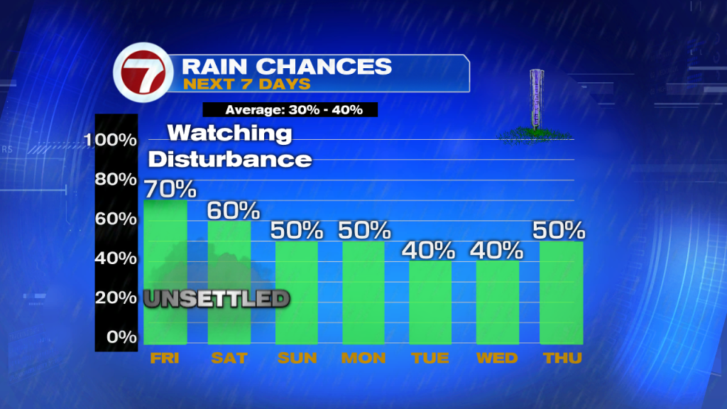
All eyes on the Tropics as a potential rainmaker inches towards Florida. A disturbance that developed over the Bahamas has developed into a low pressure system and the National Hurricane Center is keeping a close eye on it. The reason? The low is rather close to land and conditions are becoming more and more favorable for development into a tropical depression. Development chances are up to 70% as of this morning.


And while the disturbance is currently between the Bahamas & the Florida Keys, the bulk of the moisture associated with this system is primarily focused to the Northeast of the center. But as the day progresses and with the aid of daytime heating, rain and thunderstorms expected to develop and spread across South Florida, especially as this disturbance moves closer to the Florida peninsula.


So while the morning started off rather quiet, South Florida should expect rain bands & thunderstorm activity to increase as the day goes on. While gusty downpours will be possible at any given time today, waterspouts will be likely for showers offshore. And rain chances will continue to increase through the start of the weekend.


The disturbance is expected to move near or over Florida by tonight THEN push offshore again back into the Atlantic this weekend. Once it moves offshore again, that is when conditions are forecast to become better favorable for a tropical depression to develop. But regardless of development, rain will be likely across all of South Florida through the weekend….And it may be heavy at times, which could lead to street flooding.


And speaking of flooding….As we have seen in the past few weeks, it doesn’t take much for certain neighborhoods to flood, especially low-lying areas. So if you do encounter a flooded street, please do not try to drive through it. Instead, remember the phrase TURN AROUND, DON’T DROWN.

Rain will continue on and off through the weekend with a better chance for thunderstorms. So let’s keep the rain gear handy Saturday and Sunday too in case we encounter rain while you tend to your weekend errands.


Elsewhere in the tropics…The National Hurricane Center is now keeping an eye on a second area in the Central Atlantic. And while this tropical wave is still far out thee (1400 miles ESE of the Windward Island to be exact), we should definitely keep an eye on things in the days to come.

So remember to keep your umbrellas with you next few days. Looks like you will be needing them through the start of next week!
Have a great weekend!
Erika Delgado
Meteorologist
WSVN Channel 7 News
Copyright 2024 Sunbeam Television Corp. All rights reserved. This material may not be published, broadcast, rewritten or redistributed.