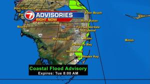
Our weekend water woes will also continue over the next couple of days. Tide troubles will remain in place for the coastal communities. Flooding on roadways from the king tides through Tuesday.

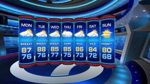
We won’t get a break from the northeast breeze for the start of work week.
This will result in a mix of sun and clouds with scattered showers and a few storms over the next few days. But, cooler and drier times appear to be around the corner. Models suggest a fall front will clear South Florida by the weekend knocking our temps to the mid to upper 60s on Sunday morning.
TROPICS
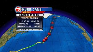
Nicole is still churning in the open Atlantic waters moving towards the north. This system will continue to stir up more hazards for the shipping lanes before it fizzles out in the cooler waters of the northern Atlantic by next week.
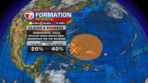
Additionally, an area of disturbed weather has popped up near The Bahamas. The National Hurricane Center is giving this feature medium chances for development over the next 5 days.
Copyright 2024 Sunbeam Television Corp. All rights reserved. This material may not be published, broadcast, rewritten or redistributed.