Happy Saturday, South Florida!
Morning, Afternoon or Night…temperatures across our area have been unseasonably warm the last week or so. And despite a few cold fronts and our once-a-week cold front pattern, temperatures have remained uncomfortable while the humidity has remained high. And it looks like South Florida will continue on this warm train for at least another day.
Clockwise rotation around a high pressure system over the Atlantic has kept our weather in check for most of the week and at the same time has allowed winds to veer out of the South/Southeast. This has not only brought moisture (in the form of humidity) back into the forecast but has also allowed temperatures to climb to uncomfortable readings.


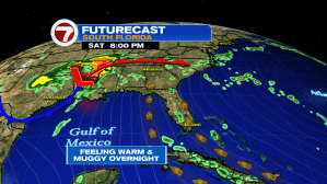
A warm ocean breeze also means that our overnight and morning temperatures will continue to run anywhere from 10-12 degrees warmer than the norm for this time of year. And tonight it will feel quite warm across our area as forecast low temperatures expected to remain in the mid to upper 70s overnight. Similar to this morning, some spots (especially down in the Keys) will remain in the low 80s all night long with a few showers pushing through the area.

And speaking of that warm ocean breeze…winds will take on a more Southerly component for the latter part of the weekend and will continue to pick up through the weekend, becoming breezy to gusty come Sunday afternoon. And while conditions out on the water started off on the quiet side for the first half of the weekend, stronger winds will have a direct impact on boating and beach conditions for the latter part of the weekend. Unfortunately Atlantic beaches are already seeing hazards starting with a high RIP CURRENT RISK.


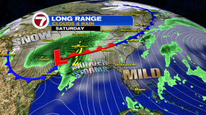
High pressure will begin to break down as a strong cold front (which has caused numerous severe thunderstorms and tornadoes across the Southern Plains, Lower Mississippi Valley and the Southeastern states this weekend) will slowly push across the Gulf of Mexico and make its way to South Florida. Luckily for us here in South Florida, the threat of severe thunderstorms will remain low with only a few showers expected to return to the forecast next week. Behind Monday’s cold front, temperatures will remain on the warm side and well above average for this time of year.


Apart from a few spotty to isolated showers, the next few days look to remain mainly dry, with the best chance for showers being on Monday with the arrival of the cold front. And after more than a week with temperatures reaching the mid to upper 80s, South Florida will be looking for some form of relief from this heat.


Unfortunately, a significant cooldown is not expected this time around. However, the front will be strong enough to at least knock overnight and morning temperatures down a few degrees. And even better…humidity levels are expected to drop for a few days behind the front! Sweaters and/or jackets won’t be needed but with the dog days of Summer right around the corner, we’ll be happy to take whatever relief we can get at this point.


So feel free to plan outdoor activities with loved ones this weekend, but be sure to keep hydrated throughout the day. AND don’t forget to APPLY AND REAPPLY that sunblock.
Have a great weekend!
Erika Delgado
Weekend Meteorologist
WSVN / Channel 7 News
Copyright 2024 Sunbeam Television Corp. All rights reserved. This material may not be published, broadcast, rewritten or redistributed.