It’s the time of year when our weather can quickly switch from sunshine to storms. Lately, the more active conditions have been inland (including Tuesday). At the beach? More sunshine overall, as clouds continued to build in the distance. Here’s a look back at the strong sunshine that persisted through Tuesday afternoon near Biscayne Bay.

We’ve not yet reached the mid point of the month, but so far in June it’s very telling to check out the differences in rain across the region. Mainland areas have been soggy, especially at official reporting stations in Ft. Lauderdale and Miami. At the other end of the spectrum we find the Florida Keys. That’s where we’re still waiting for the first bit of measurable rain this month! Even more impressive is the fact that Key West has been dry all the way since May 17th.

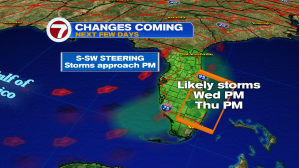
As we begin Wednesday, the weather map shows us south of a frontal boundary with nearly calm winds.

We’ll continue with the set up for afternoon and evening storms, mainly close to the southeast coast. Earlier in the day, the heat with build along with more clouds (from the south and west).
Looking ahead into the weekend, a notable change includes a more onshore pattern. East to southeast winds will make for a small amount of “heat relief”. Coastal areas will also detect a helpful breeze. Finally, the steering pattern will shift any developing rain and storms to the west.
