The feel of fall is still far from us this week. Here’s evidence across south Florida with actual highs on Wednesday. Keep in mind that the lower 80’s are usually common this time of the year.

We’ve been getting our fair share of sunshine with only limited batches of clouds arriving from the east.

Distant high pressure is controlling our south Florida weather pattern. The storm track is currently north of the state where we’re seeing an impressive frontal boundary. Along it, there are a couple of low pressure centers marching from west to east. For now, the disturbances are too far removed for unsettled weather to come directly into our region. The onshore flow, however, may allow for a brief shower wandering in from the Atlantic.

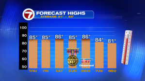
Warmer than average temperatures will continue through the upcoming weekend. Here’s a check on forecast highs.
The next weather change will not be one that allows temperatures to cool back. A weakening front will likely stall out in the vicinity during the upcoming weekend (possibly prompting a few more areas of rain). Then, things could turn more interesting by the middle of next week. A stronger cold front than we’ve seen in awhile is forecast to dive southward by next Wednesday. This could scale back readings to more typical “fall levels” locally in south Florida. While not a drastic drop, we may get more pleasant air along with lower humidity levels. Nighttime lows may fall into the middle to upper 60’s. This might be welcomed, along with a comfortable and strengthening breeze.
