Happy Saturday, South Florida.
Looks like the days of cold fronts arriving to South Florida bringing a nice change in the air are long gone….for South Florida at least. It was nice while it lasted though. With temperatures reaching into the upper 80s and low 90s last few days, it has been feeling more like Summer than Spring in South Florida….and unfortunately the heat and humidity are here to stay for a while.
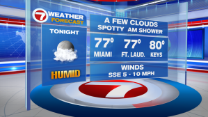
The thunderstorms we saw develop earlier have since fizzled out, leaving only warm and muggy conditions overnight into Sunday morning. With winds out of the South/Southeast, humidity will remain high as moisture from the Atlantic continues to stream in. A spotty shower is possible overnight along coastal areas, including Sunday morning.
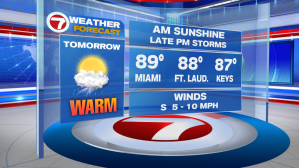
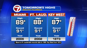
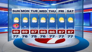
Speaking of Sunday….high pressure remains well off shore and a weak front will slowly slide south across our Sunshine State. A southerly wind will allow afternoon temperatures across South Florida to once again soar into the 80s, with some spots reaching the low 90s. This will put some areas close to nearing previous record high temperatures.
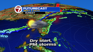
Sunday should start sunny and steamy and should remain that way through the first half of the day. As temperatures continue to warm and both the Gulf and Atlantic SeaBreezes form, afternoon thunderstorms will once again begin to develop. First we’ll see them popping up across Interior areas and then the Southwest steering flow will eventually steer them towards the East Coast metro areas. So while storms will be present through the afternoon, it might take a bit for them to actually reach East coast metro areas.
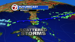
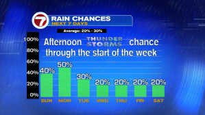
Looks like the work week will start off with a similar stormy setup, with a slightly higher thunderstorm coverage than this weekend. We can thank a Westerly steering flow for that! THat weak front finally arrives near South Florida but won’t clear our area. While we won’t be expecting a cooldown with this front, at least these stormy afternoons will be out of the forecast for the rest of the week, leaving for warm temperatures and mostly sunny days through the start of the next weekend. Now THAT’s something to look forward to!
Enjoy the rest of your weekend. Please be safe out there!
Erika Delgado
Weekend Meteorologist
WSVN Channel 7 / WSVN
Copyright 2024 Sunbeam Television Corp. All rights reserved. This material may not be published, broadcast, rewritten or redistributed.