Happy Monday, South Florida!
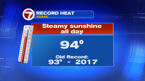
Another day, another afternoon with record-smashing high temperatures in Miami. But why have temperatures across South Florida been so steamy lately? The culprit: a WEST TO SOUTHWEST WIND!

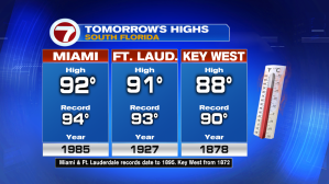
As we head into day 2 of the work week, steamy temperatures will once again return to the forecast. This should allow afternoon high temperatures on Tuesday to soar into the 90s and flirting with near-record high temperatures once again.
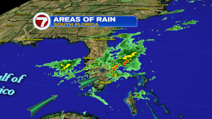
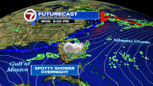
As if these scorching hot temperatures didn’t already make it feel like Summer had arrived, it seems that all thunderstorm activity next few days will also favor the East Coast metro areas. So the STORMY WEATHER PATTERN that we have experienced on Sunday and Monday, sticks around for a little bit.
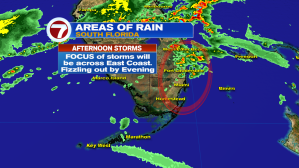
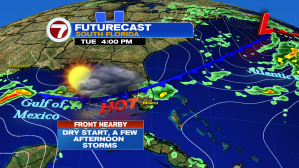

Without the ocean influence, overnights and mornings should remain mostly dry next few days while afternoons remain steamy then turn stormy across South Florida. All the while, a weak front will continue to drift south across our State helping to trigger thunderstorms across the Southern half of our state.
As if that weren’t enough, a few disturbances will cross near South Florida, also allowing for that thunderstorm chance to remain present through much of the upcoming work week.
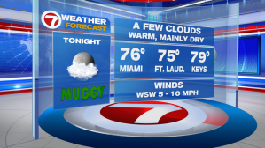
By the end of the work week, the return of the ocean breeze will help moderate temperatures a bit. By no means are we expecting comfortable temperatures but at least afternoon high’s will be closer to average. (We’ll take what we can get!)


So while South Florida got a break from the afternoon thunderstorms last few days, it looks like that stormy weather pattern is back in the forecast and looks to remain in place for at least the next 4-5 days. Let’s look at the bright side of all of this – at least our lawns will be looking green and luscious as we head into the dog days of Summer!

Have a great work week!
Erika Delgado
Weekend Meteorologist
WSVN 7 News
Copyright 2024 Sunbeam Television Corp. All rights reserved. This material may not be published, broadcast, rewritten or redistributed.