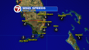
We’re about to go from warm to warmer. A persistent southerly air flow is the main reason why. Here’s a look at winds from late Saturday afternoon. The warm breeze continued along the southeast coast and was decreasing during the day. It’s worth noting that our overnight winds will go nearly calm. Areas of fog could form just before daybreak Sunday. The more substantial risk of dense fog will be across interior south Florida.
Officially, the spring season is a month away. Even so, south Florida temperatures and humidity values will more resemble March (if not April) compared to the middle of February!

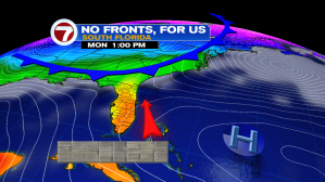
As the Holiday weekend continues, the only weather change includes a weak front that will sneak into north Florida. The cold front won’t be able to make much more progress than perhaps the Orlando vicinity. Just the same, a few showers could get triggered even well removed from the boundary.
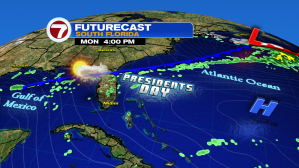
A blocking weather pattern is taking shape and that will “fend off” Monday’s front, as well as other disturbances. High pressure, located east of the Bahamas, will keep us both quiet and extra warm.
By the way, the biggest Supermoon of the year is on Tuesday night, February 19th. We’ll be talking about it as the event gets closer. In short, the moon will appear larger and brighter due to the “closer” proximity to earth.
